Cranberry Lake
Cranberry Lake is a 6,995-acre impoundment of the Oswegatchie River on the edge of the Five Ponds Wilderness, and one of the largest brook trout waters in the eastern United States. Shallow, tannic, and rimmed by miles of roadless Forest Preserve shoreline, it is classic Adirondack canoe-and-fly-rod water.
Overview
Cranberry Lake sprawls across 6,995 acres of the western Adirondacks in the town of Clifton, St. Lawrence County, where a dam on the Oswegatchie River backs the tannin-stained water into a maze of flows, bays, and islands pressed against the Five Ponds Wilderness. It is one of the largest lakes inside the Adirondack Park, yet it feels nothing like the busy resort lakes to the east. Most of the shoreline is roadless Forest Preserve, reachable only by boat or trail, and the far bays are as wild as stillwater fishing gets in New York.
What makes Cranberry remarkable for a fly angler is its scale as brook trout habitat. The lake is managed for brook trout, and the state backs that management with one of the largest brookie stockings in New York: the 2022 DEC actual stocking report lists 27,000 brook trout for Cranberry, 20,000 fall fingerlings and 7,000 yearlings. Spread across a lake this size the fish disperse into countless flows and shoreline pockets, and Cranberry has earned its reputation as one of the largest brook trout waters in the eastern United States.
The character of the water shapes the fishing. Cranberry is shallow, with a mean depth of just 5.9 feet against a maximum of 38, and its bog-stained flows warm quickly in summer. That makes the calendar simple: the prime fly windows run from ice-out through June and again from mid-September until the season winds down, when brook trout spread across the flats and shoreline shallows within easy reach of a floating or intermediate line. Slow-stripped small Woolly Buggers and traditional Adirondack wet flies over the flats are the bread-and-butter approach, and evening caddis and speckled-wing spinner falls bring fish to the surface in the wilderness bays of Dead Creek Flow and South Flow.
Brook trout are the headliners, but smallmouth bass share the lake and keep rods bent through the warm months when the trout turn dour, working the rocky points and drowned wood on buggers and baitfish patterns. Yellow perch and brown bullhead round out the community listed on the DEC contour map.
Cranberry rewards the angler who treats it as an expedition rather than a boat-ramp stop. A canoe, kayak, or small motorboat opens up miles of wilderness shoreline and primitive campsites, and a multi-day trip that pairs morning wet-fly work in the flows with evening rises in the back bays is one of the great traditional fly-fishing experiences left in the Northeast. Bring a map, watch the wind on the open middle of the lake, and fish the edges where the dark water meets the forest.
Depth & Character
- Surface Area
- 6,995acres
- Max Depth
- 38ft
- Mean Depth
- 5.9ft
- Elevation
- 1,485ft
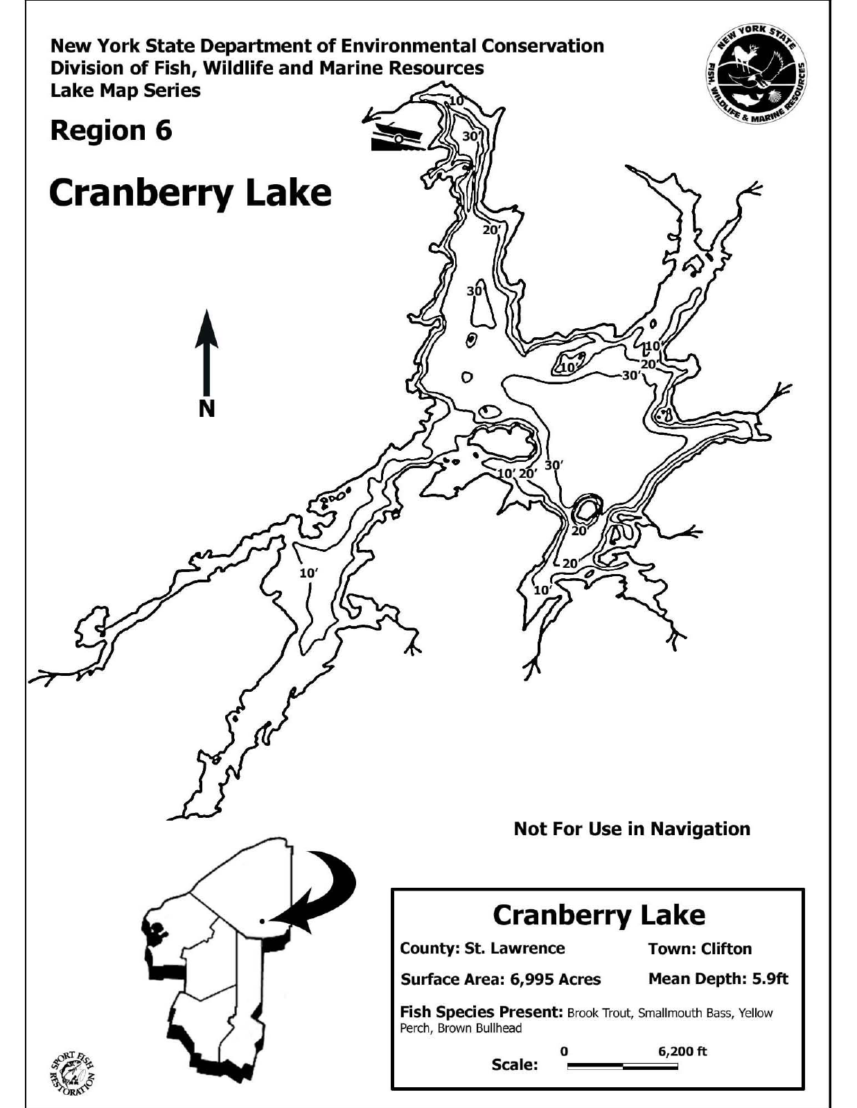
Bathymetric depth chart — click to open the full PDF. Source: Vermont DEC.
Source: Vermont DEC
Water Characteristics
Cranberry Lake is a shallow, tannic flowage rather than a deep glacial basin. The DEC contour map shows a lake that averages only 5.9 feet deep and bottoms out at 38 feet, with broad flats, bog-stained flows, and long finger bays radiating off the main body. The dark, tea-colored water is typical of Oswegatchie drainage bog country: fish are less leader-shy than in clear Adirondack lakes, but they rely on the low light and stained water to feed shallow.
Because the lake is so shallow, it lacks the classic two-story thermal refuge of the deep trout lakes; instead, brook trout shift seasonally, spreading across the flats and bay mouths in the cool months and tightening to cooler water, spring influence, and depth through midsummer. The soft-bottomed flows and weedy bay margins carry the insect biomass, with caddis, speckled-wing mayflies, damselflies, dragonflies, and leeches concentrated where the wilderness streams enter, notably Dead Creek Flow and South Flow.
For a fly angler reading the contour sheet, the useful structure is the transition water: the 10-to-20-foot troughs adjacent to big flats, the old river channel toward the dam, and the mouths of the flows. Those edges are where brook trout stage between feeding pushes onto the shallows.
Stocking
| Species | Size | Number | Program |
|---|---|---|---|
| Brook Trout | Fall fingerling (4.5 in) | 20,000 | NYSDEC annual stocking, Town of Clifton (2022 actual) |
| Brook Trout | Yearling (8 in) | 7,000 | NYSDEC annual stocking, Town of Clifton (2022 actual) |
Seasonal Fishing Guide
Spring
Ice-out through June is the prime window. Brook trout spread across the shallow flats and shoreline edges, and a floating or intermediate line covers everything. Slow-strip small Woolly Buggers, swing soft-hackle wets in pairs off the flow mouths, and watch for early caddis in the bays. The stained water means fish feed shallow even at midday early in the season.
Summer
The shallow, tannic water warms quickly and brook trout become harder to reach by July. Fish dawn and dusk near cooler water and the deeper troughs shown on the contour map, or switch targets: smallmouth bass eat buggers, Muddlers, and surface flies around rocky points and drowned wood all summer. Evening caddis and spinner activity in Dead Creek Flow and South Flow can still bring trout up on cooler nights.
Fall
After mid-September, cooling water pulls brook trout back onto the flats and toward the flow mouths, and the lake fishes much like spring with the bonus of aggressive, brightly colored pre-spawn fish. Streamers and wets along the wilderness shorelines are the play; this is the best big-fish window of the year.
Winter
The lake freezes at this elevation, but winter is the off-season for the fly fishery. If you are considering hardwater fishing, check current NYSDEC Region 6 special regulations first, as ice-fishing rules on Adirondack trout waters vary by waterbody.
Access & Boats
The primary access is the DEC hard-surface boat ramp off Route 3 at the outlet dam on the north end of the lake. A wheelchair-accessible hand launch at South Columbian Road serves canoes, kayaks, and cartop boats, and the DEC Cranberry Lake Campground provides camping with lake access. Beyond those developed points, miles of roadless Forest Preserve shoreline are open to canoe camping at primitive sites, which is the classic way to fish the wilderness flows. Float tubes and canoes are well suited to the sheltered bays; the open main lake deserves respect in wind.
Ice Fishing
Cranberry Lake sits at 1,485 feet in the western Adirondacks and ices over in winter, but winter fishing here is not the draw that the open-water brook trout seasons are. Region 6 special regulations govern the lake, and ice-fishing rules for trout waters in the Adirondacks vary by waterbody, so verify current Region 6 regulations before planning any hardwater trip.
Fishing Pressure & Local Tips
Light to moderate, and concentrated near the village and boat ramp at the north end. Cranberry's size, its roadless shoreline, and the effort required to reach the back flows keep pressure remarkably low for a lake with this much stocked and holdover brook trout biomass. Paddle twenty minutes into Dead Creek Flow or South Flow on a weekday and you will likely have wilderness bays to yourself; even in summer, most traffic is campers and paddlers rather than anglers.
Local Knowledge
Fish the shoulder seasons and fish the edges. From ice-out through June, brook trout roam the flats and bay shorelines: slow-strip a size 8-10 Woolly Bugger or swing a brace of traditional wet flies on a floating or intermediate line along the dark-water edges where flows enter the lake. The take is often a soft tightening rather than a grab, so keep the rod low and strip-set gently.
Save your evenings for the wilderness bays. Dead Creek Flow and South Flow produce evening caddis activity and speckled-wing spinner falls in the warm months, and a canoe positioned off a rising pod at dusk is the best dry-fly opportunity on the lake. Carry Elk Hair Caddis and a few spinner-style mayfly patterns and be patient; brook trout in the stained water often cruise a beat rather than hold a lie.
When July heat pushes the trout down, switch to smallmouth on the rocky points and drowned timber with buggers and Muddlers, then return for the brook trout after mid-September, when cooling water brings them back to the flats in their brightest fall colors.
Species Present
Brook Trout
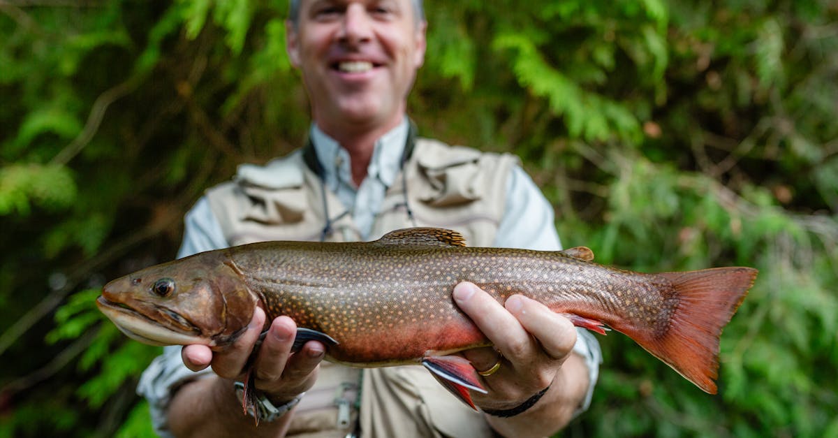
The brook trout is widely considered the most beautiful freshwater fish in North America, and catching one in a pristine Montana mountain stream is an experience that captures the essence of backcountry fly fishing. Despite their common name, brook trout are not true trout at all; they are a species of char (genus Salvelinus), more closely related to lake trout and Arctic char than to rainbows or browns. Native to eastern North America from Georgia to Hudson Bay, brook trout were among the first salmonids introduced to Montana's waters in the late 1800s and have since established self-sustaining populations in cold, high-elevation streams and lakes throughout the state. In Montana, brook trout thrive best in small, cold headwater streams and high mountain lakes where competition from larger trout species is minimal. In these environments, they are often the dominant, or only, salmonid present. The trade-off is size: Montana stream-dwelling brook trout typically range from 6 to 10 inches, with fish over 12 inches considered noteworthy in most waters. What they lack in size, however, they more than make up for in beauty and willingness to eat a fly. Brookies are aggressive feeders that will strike attractor dry flies, nymphs, and small streamers with enthusiasm, making them an ideal species for beginning fly anglers and a delightful quarry for anyone who appreciates small-stream fishing. Brook trout do present a conservation paradox in Montana. While they are a beloved and beautiful gamefish, they are non-native and can negatively impact native species, particularly Yellowstone and westslope cutthroat trout. In headwater streams, brook trout often outcompete cutthroats for food and spawning habitat due to their higher reproductive rate and earlier maturation. As a result, Montana FWP has implemented brook trout removal projects on some streams to restore native cutthroat populations. In many waters, liberal harvest limits for brook trout are encouraged to reduce their numbers and benefit native fish. Anglers can enjoy excellent brook trout fishing while actively helping conservation by keeping a few for the pan.
Smallmouth Bass
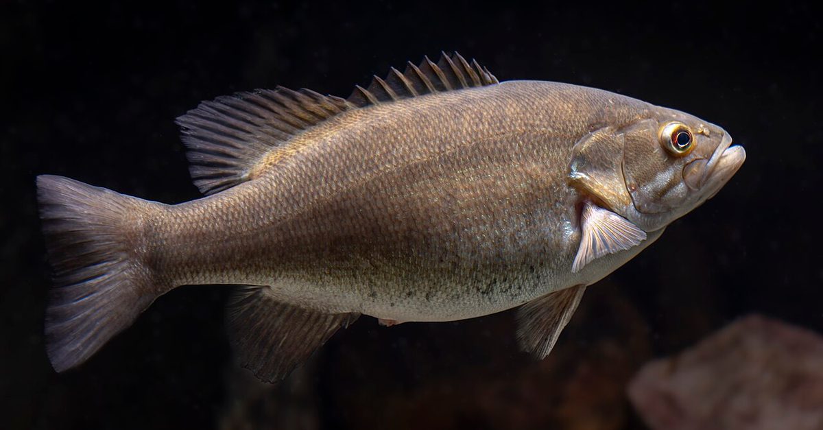
The smallmouth bass is one of the most popular and widely distributed gamefish in North America and one of the finest freshwater species available to fly anglers. Found in clear, cool rivers and lakes from the Great Lakes to the Southern Appalachians, smallmouth bass combine aggressive feeding behavior, remarkable fighting ability, and a preference for the kinds of rocky, current-rich habitats that are ideally suited to fly fishing. Pound for pound, the smallmouth bass is widely considered the hardest-fighting freshwater fish in North America, earning it the nickname 'the bronze bomber' for its explosive takes and powerful, acrobatic battles on the end of a line. While smallmouth bass are not a traditional trout-stream species, they have become increasingly important to fly anglers as warm-water fly fishing has grown in popularity. Rivers like the French Broad in North Carolina, the Susquehanna and Delaware in Pennsylvania, and the St. Lawrence in New York support world-class smallmouth fisheries that attract dedicated fly anglers. In many regions, smallmouth bass inhabit the lower reaches of the same river systems that hold trout in their upper reaches, providing fly anglers with a warm-water counterpart to their cold-water fishing. Smallmouth bass are particularly appealing to fly anglers because they readily take surface flies. On warm summer evenings, smallmouth will crush poppers, sliders, and large dry flies with explosive strikes that rival any trout rise. Their willingness to feed on the surface, combined with their strength and acrobatic leaping ability, makes smallmouth bass on a fly rod one of the most thrilling freshwater fly fishing experiences available.
Food Sources & Hatches
| Insect | Suggested Fly | Jan | Feb | Mar | Apr | May | Jun | Jul | Aug | Sep | Oct | Nov | Dec |
|---|---|---|---|---|---|---|---|---|---|---|---|---|---|
Chironomids (midges) Morning and evening | Chironomid (Bomber) | ||||||||||||
Speckled-wing mayflies (Callibaetis-type) Late morning and evening | Sparkle Dun | ||||||||||||
Caddisflies Evening | Elk Hair Caddis | ||||||||||||
Damselflies Morning to midday | Damselfly Nymph | ||||||||||||
Dragonflies All day | Dragonfly Nymph | ||||||||||||
Leeches All day, best in low light | Woolly Bugger |
Chironomids (midges): Steady midge activity over the soft-bottomed flows and bay margins from ice-out through fall. Suspend pupae over the 8-15 foot transitions off the flats, or fish a Griffith's Gnat to sipping fish on calm evenings.
Speckled-wing mayflies (Callibaetis-type): Speckled-wing spinner falls in the wilderness bays, especially Dead Creek Flow and South Flow, bring brook trout to the surface. A Sparkle Dun or spent-wing pattern in 14-16 covers duns and spinners.
Caddisflies: Evening caddis activity in the back bays and along the wilderness shorelines is the most reliable dry-fly event of the warm months. Skitter an Elk Hair Caddis over cruising fish at dusk.
Damselflies: Damsel nymphs migrate toward weedy bay edges and emergent cover in early summer. A slow hand-twist retrieve with an olive nymph along the weedlines takes both brook trout and smallmouth.
Dragonflies: Dragonfly nymphs prowl the drowned wood and weedy flats of this shallow flowage all season. Crawl a nymph pattern near bottom structure; a favorite searching fly for the bigger smallmouth.
Leeches: Leeches thrive in the tannic, soft-bottomed water and are the number-one searching food form. Slow-strip small buggers and leech patterns over the flats in spring and fall; black and olive both produce in the stained water.
Recommended Flies
Woolly Bugger
Top PickThe signature Cranberry fly. Slow-strip a size 8-10 olive or black bugger over the flats and along flow mouths whenever brook trout are shallow.
Best in Spring and fall
Black Woolly Bugger
Top PickBlack shows up best in the tea-stained water. Doubles as a leech and a baitfish; fish it on a floating or intermediate line along dark-water edges.
Best in Spring through fall
Soft Hackle Wet Fly
Top PickTraditional wet flies are Adirondack heritage tactics on Cranberry. Swing a two-fly brace of soft hackles across the flow mouths and flats for cruising brook trout.
Best in Spring and fall
Elk Hair Caddis
Top PickCovers the evening caddis activity in the wilderness bays. Twitch or skate it at dusk in Dead Creek Flow and South Flow.
Best in Late spring through summer
Access Points & Boat Launches
DEC Boat Launch at the Outlet Dam (Route 3)
Boat LaunchEasyHard-surface DEC ramp off Route 3 at the Oswegatchie outlet dam at the northeast end of the lake. The main trailer-boat access and the natural starting point for trips down the lake toward the wilderness flows.
South Columbian Road Hand Launch
Boat LaunchEasyWheelchair-accessible hand launch on South Columbian Road, suited to canoes, kayaks, and cartop craft. A convenient put-in for paddlers working the near bays without contending with the trailer ramp.
Cranberry Lake Campground (DEC)
ParkingEasyState campground on the lake with camping and shoreline access, a practical base for multi-day fishing trips. Beyond the campground, miles of roadless Forest Preserve shoreline offer primitive boat-in campsites for canoe-camping anglers headed to the wilderness bays.
Regulations
Regulations
Cranberry Lake falls under NYSDEC Region 6 special regulations, and statewide New York freshwater fishing rules apply where no special regulation is listed. A New York fishing license is required. Because Adirondack trout-water seasons, size limits, and bag limits are adjusted periodically, always verify the current regulations for Cranberry Lake on the NYSDEC website or in the current fishing regulations guide before fishing.
Always verify current regulations with Montana Fish, Wildlife & Parks before fishing.
Quick Facts
- Surface Area
- 6,995 acres
- Max Depth
- 38 ft
- Elevation
- 1,485 ft
- Lake Type
- Reservoir
- Region
- Adirondacks / St. Lawrence County
- Best Seasons
- spring, fall
- Species
- Brook Trout, Smallmouth Bass
- Difficulty
- Beginner to Intermediate
- Record Fish
- Cranberry holds no headline state records, but its claim to fame is bigger than any single fish: it is regarded as one of the largest brook trout waters in the eastern United States, sustained by one of New York's heaviest annual brook trout stockings.
- Depth Chart
- Download PDF
Nearby Lakes & Ponds
Lake Placid
Adirondack High Peaks / Essex County
Stillwater Reservoir
Beaver River Country / Herkimer County
Skaneateles Lake
Finger Lakes / Onondaga, Cortland & Cayuga Counties
Lake George
Adirondacks / Warren, Essex & Washington Counties
Schroon Lake
Adirondacks / Warren & Essex Counties
Otsego Lake
Leatherstocking / Otsego County (Cooperstown, DEC Region 4)